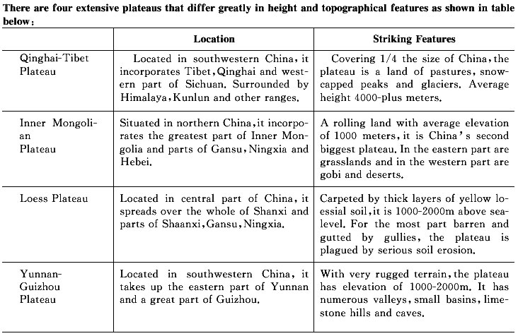
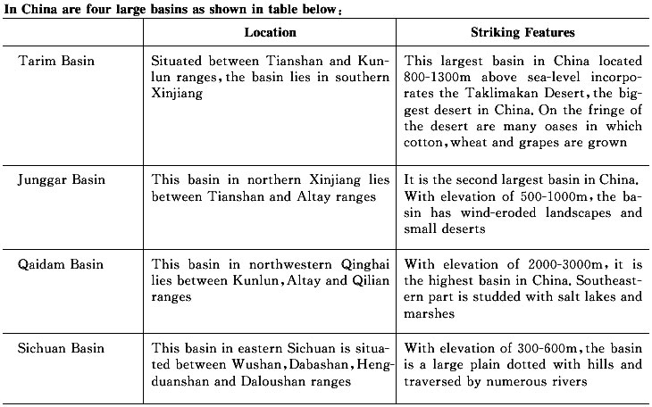
|
(Map source: SBSM.gov.cn)
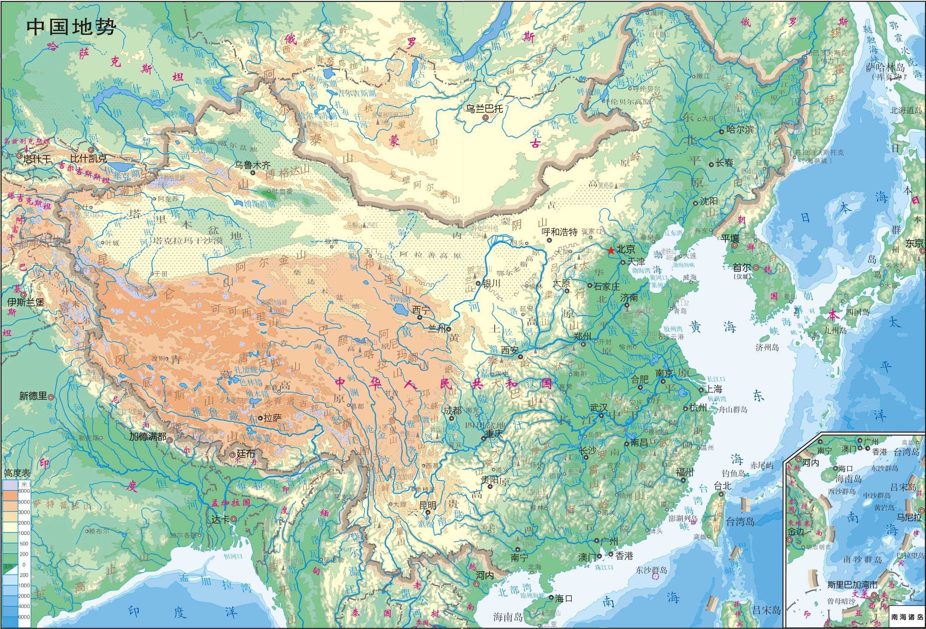
The topography varies greatly in China, a vast land of lofty plateau, large plains, rolling land and big and small basins surrounded by lofty mountains. All the five basic topographic types in the world exist in China to create the conditions for developing industry and agriculture.
Mountainous land and very rough terrains make up 2/3 of Chinese territory, and this has created some problems in transport and in the development of agricultural production. However such topographical features are conducive to the development of forestry, mineral and hydropower resources and tourism.
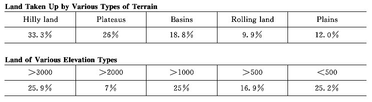
With highlands in the west and plains in the east, China has a varied topography. The lie of the land may be divided into three tiers. The Qinghai-Tibet Plateau that rises more than 4, 000m above sea-level forms the highest tier. It is a land of peaks and valleys studded with innumerable lakes. Along the plateau's southwestern fringe is the Himalayan Range, on the eastern section of which looms the 8, 848. 13 meter-high Mt. Qomolangma, the world's loftiest peak. The vast area north and east of the Qinghai-Tibet Plateau that drops to an elevation below 1, 100-2, 000m forms the second tier-a land interspersed with extensive basins and highlands. Here the Turpan Basin in Xinjiang is 154m below sea-level-the lowest depression in China. The third tier is a vast area of rolling hills and plains with an elevation below 500m lying east of the line running from the Greater Hinggan and Taihang ranges in the north to the foothills of the Wushan Mountains and the Yunnan-Guizhou Highlands in the south. Though some peaks in this area are as high as 2, 000m, the plains along the coast have an elevation of less than 50m. Off the Chinese coast is an extensive continental shelf richly endowed with petroleum, natural gas and marine resources.
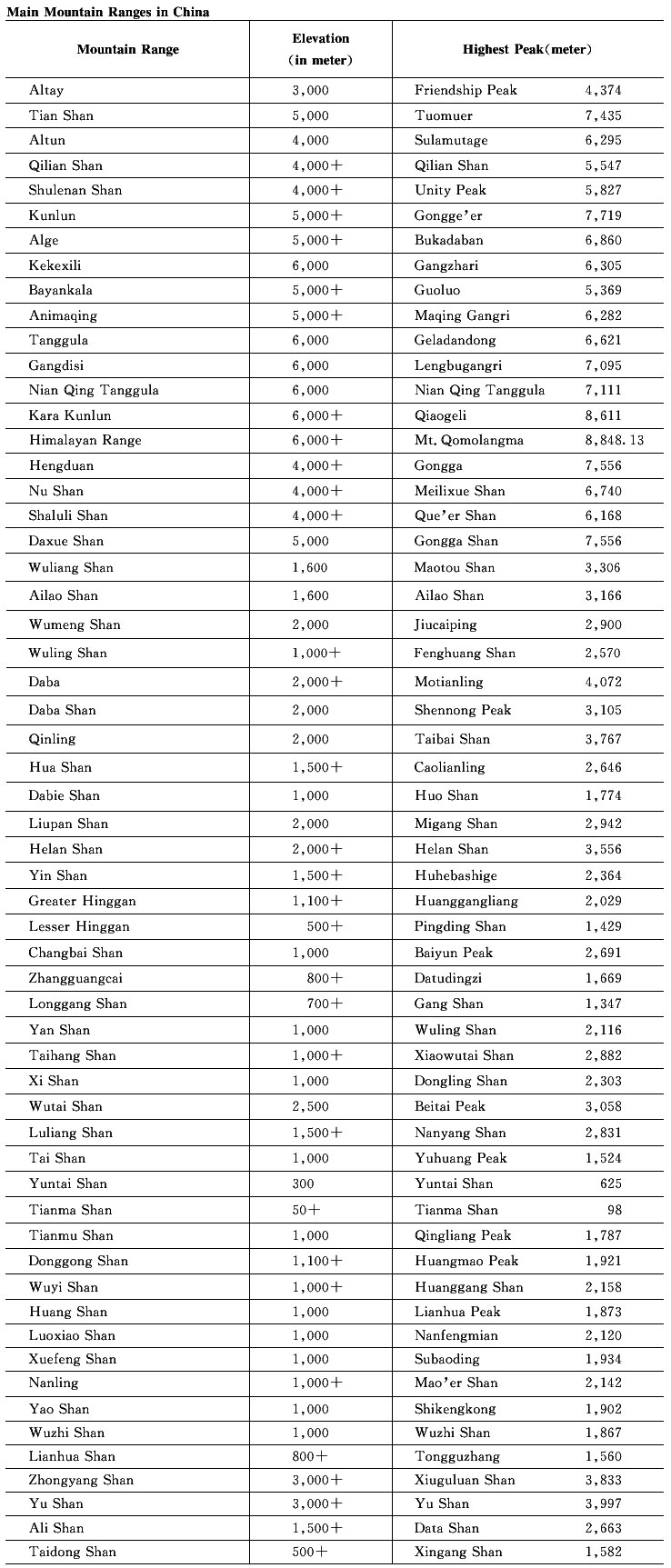
There are many mountain ranges in China. Those extending from east to west are the Tianshan-Yinshan ranges and those in the center are the Kunlun-Qinling ranges, and those in the south are the Nanling ranges. Ranges that stretch in a NE-SW direction are, for the most part, located in the eastern part of China. They are the Greater Hinggan Range, Taihang, Wushan, Xuefengshan, Changbaishan and Wuyishan ranges. Those running in a NW-SE direction are the Altai and Qilianshan ranges. Ranges that run in a north-south direction are the Hengduanshan and Helanshan ranges. And on the border between China and India, Nepal and other countries looms the 2, 400 kilometers-long Himalayan Range with an average elevation of 6, 000m.
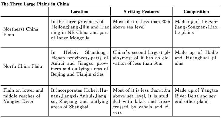
In China are three large plains with fertile soil, on which crops grow in luxuriant, as well as many small ones in the Chengdu area, the Pearl River Delta, western Taiwan Province and other areas:
|